Home › Festivals › Gwanak Gang Gam-chan Festival
Gwanak Gang Gam-chan Festival 2026
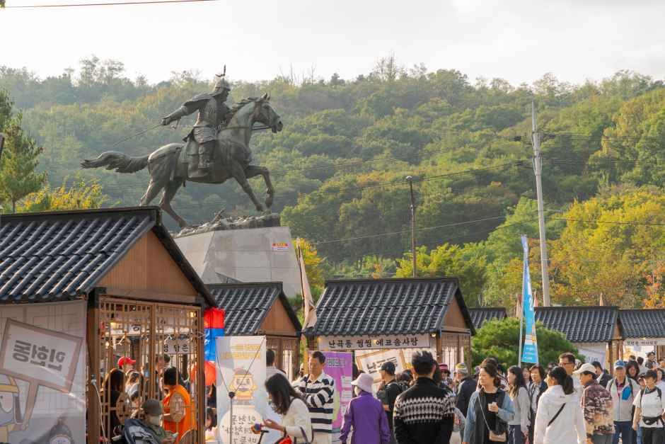
- 📅 Dates
- Oct 16, 2026 – Oct 18, 2026
- 📍 Location
- 77 Nakseongdae-ro, Gwanak-gu, Seoul
- 🎫 Admission
- Free
- 🕘 Hours
- 13:00-21:00
- 🎪 Venue
- Nakseongdae Park
- 🏛️ Organizer
- Gwanak-gu District · Gwanak Culture Association
- ☎️ Contact
- +82-2-828-5765
Overview
The Gwanak Gang Gam-chan Festival is a historical and cultural event held to honor the patriotic spirit of General Gang Gam-chan, a famous general from the Goryeo Dynasty. The festival is known for its impressive night events, fitting for the location named after a falling star, and features a variety of parades and performances. ◎ Gang Gam-chan and Nakseongdae General Gang Gam-chan of Goryeo is said to have been born at the place where the fourth star of the Big Dipper fell. This place is called Nakseongdae, which means “the place where the star fell.”
Source: Korea Tourism Organization (official English translation, TourAPI).
🇰🇷 Copy this into Naver Map or Kakao Map
Google Maps cannot give walking or transit directions inside Korea — Korean law restricts map-data export. Naver Map and Kakao Map can, but they find far more when you search in Korean. Copy and paste:
Paid linkBoth apps need mobile data while you are out and about. A Korea eSIM can be bought before you fly → Compare Korea eSIMs on KlookWe earn a commission if you book through this link. Your price is the same.
📊 How busy this area gets
Visitor-volume index for 관악구, from Korea Tourism Organization big data. 1.00 = that area's own yearly average, so this compares the area against itself — not against Seoul.
Oct — 1.07
The index covers the whole district, not the festival ground itself. Use it to pick a month, not a day. · Apr 1.02 / Aug 1.09
🅿️ Nearby attractions — with actual parking capacity
Most sites only say "parking available." These are official figures from the Ministry of the Interior and Safety, so you can judge before you drive.
Names and addresses here stay in Korean on purpose. Google Maps cannot give directions inside South Korea, and NAVER Map / KakaoMap find these places only under their Korean names — copy an address above and paste it straight in.
🏮 Traditional market days during the festival
Korean country markets open only on days ending in fixed digits — every 5 days. These are the actual dates they open while the festival runs, so you can add one to the same trip.
Names and addresses here stay in Korean on purpose. Google Maps cannot give directions inside South Korea, and NAVER Map / KakaoMap find these places only under their Korean names — copy an address above and paste it straight in.
🎪 Other festivals nearby at the same time
Overlapping dates, within 60 km.
Nearby Attractions
Places near the festival venue, described in English by the Korea Tourism Organization. Distances and times are road-based driving estimates from NAVER route search — useful for taxi trips — and can change with traffic. Places under 1 km in a straight line are marked “walkable”. Anything more than 15 km away by road is left out.
-
Nam-Seoul Museum of Art (SeMA)서울시립미술관 남서울생활미술관 Attractionapprox. 2.8 km · ~8 min by car
The Nam-Seoul Museum of Art offers visitors a meaningful opportunity to linger beside the traces of history. The building previously served as the Belgian Consulate…
Korean address for map apps서울특별시 관악구 남부순환로 2076 -
Gyujanggak Library of Seoul National University서울대학교 규장각 Cultural facilityapprox. 3.6 km · ~9 min by car
Gyujanggak Library was founded in 1776 during the reign of King Jeongjo, the 22nd ruler of the Joseon dynasty, at which time it was located within the Changdeokgung…
Korean address for map apps서울특별시 관악구 관악로 1 -
Seoul National University서울대학교 Cultural facilityapprox. 3.6 km · ~9 min by car
Founded in 1946, Seoul National University is the most reputable university in Korea based on its long academic history and tradition. It was the first national…
Korean address for map apps서울특별시 관악구 관악로 1 -
MEDIPACT메디팩트 Attractionapprox. 2.7 km · ~11 min by car
Medipact is a company that provides an integrated medical platform encompassing foreign patient attraction, global influencer marketing, and interpretation support…
Korean address for map apps서울특별시 관악구 봉천동 975-21 -
Gwanaksan Mountain관악산 Attractionapprox. 4.7 km · ~11 min by car
Reaching 632.2 meters in x_height, Gwanaksan Mountain is the symbol and pride of Gwanak-gu district in Seoul. Most of the cultural heritage of the district originates…
Korean address for map apps서울특별시 관악구 관악로
Google Maps cannot provide driving or transit directions inside South Korea. Paste the Korean addresses above into NAVER Map or KakaoMap — both work with these addresses and are what people here actually use.
Other festivals in Seoul
← Browse all festivals in Seoul
Taking Seoul home
A small Korean brand called kory puts city names on everyday things — hair rollers, hair ties, claw clips, scarves.
We help make kory, so this is not a paid placement — but it is a link we have an interest in. That is why it sits here at the bottom and nowhere else. Product pages and the shop home are in English; a few other pages there are still Korean only.