Home › Festivals › Seoul Petlympics
Seoul Petlympics 2026
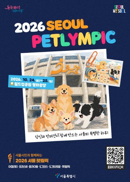
- 📅 Dates
- Oct 24, 2026 – Oct 25, 2026
- 📍 Location
- 243-48 World Cup-ro, Mapo-gu, Seoul
- 🎫 Admission
- Free admission- Petlypics event participation 40,000 won / Dog trail 40,000 won
- 🕘 Hours
- 10:00-17:00
- 🎪 Venue
- Peace Plaza at World Cup Park
- 🏛️ Organizer
- Seoul Metropolitan City · Korean Agility Federation, Inc.
- ☎️ Contact
- 0502-1949-0514
Overview
The Seoul Petlympics is an urban dog sports festival where citizens and their dogs can run, walk, and take on challenges together to create special memories. Held at Peace Plaza in Seoul World Cup Park, the event features a variety of participatory programs designed so that not only professional athletes but also citizens and their dogs who are new to dog sports can enjoy the experience together. In addition to the Petlympics—featuring challenges open to everyone, such as “Wait,” “Come,” “S-Curve Obstacle,” and the “15-Meter Dash”—the event will also include the “Dog Trail,” where participants
Source: Korea Tourism Organization (official English translation, TourAPI).
🇰🇷 Copy this into Naver Map or Kakao Map
Google Maps cannot give walking or transit directions inside Korea — Korean law restricts map-data export. Naver Map and Kakao Map can, but they find far more when you search in Korean. Copy and paste:
Paid linkBoth apps need mobile data while you are out and about. A Korea eSIM can be bought before you fly → Compare Korea eSIMs on KlookWe earn a commission if you book through this link. Your price is the same.
📊 How busy this area gets
Visitor-volume index for 마포구, from Korea Tourism Organization big data. 1.00 = that area's own yearly average, so this compares the area against itself — not against Seoul.
Oct — 1.07
The index covers the whole district, not the festival ground itself. Use it to pick a month, not a day. · Aug 1.06 / Oct 1.07
🅿️ Nearby attractions — with actual parking capacity
Most sites only say "parking available." These are official figures from the Ministry of the Interior and Safety, so you can judge before you drive.
Names and addresses here stay in Korean on purpose. Google Maps cannot give directions inside South Korea, and NAVER Map / KakaoMap find these places only under their Korean names — copy an address above and paste it straight in.
🏮 Traditional market days during the festival
Korean country markets open only on days ending in fixed digits — every 5 days. These are the actual dates they open while the festival runs, so you can add one to the same trip.
Names and addresses here stay in Korean on purpose. Google Maps cannot give directions inside South Korea, and NAVER Map / KakaoMap find these places only under their Korean names — copy an address above and paste it straight in.
🎪 Other festivals nearby at the same time
Overlapping dates, within 60 km.
Nearby Attractions
Places near the festival venue, described in English by the Korea Tourism Organization. Distances and times are road-based driving estimates from NAVER route search — useful for taxi trips — and can change with traffic. Places under 1 km in a straight line are marked “walkable”. Anything more than 15 km away by road is left out.
-
World Cup Park월드컵공원 Attraction0.1 km straight · walkable
Opened on May 1st, 2002, the Wolrd Cup Park was once a 15-year-old landfill that held over 92 million tons of garbage. The park is located near Seoul World Cup Stadium,…
Korean address for map apps서울특별시 마포구 월드컵로 243-60 (성산동) -
Seoul World Cup Stadium서울월드컵경기장 Travel course0.6 km straight · walkable
Seoul World Cup Stadium, constructed for the 2002 World Cup co-hosted by South Korea and Japan, stands as the largest soccer-specific stadium in Korea. Currently serving…
Korean address for map apps서울특별시 마포구 월드컵로 240 (성산동) -
Football Faentasium풋볼 팬타지움 Cultural facility0.7 km straight · walkable
Football Faentasium is the first soccer-themed experience museum in Korea, founded by the Korea Football Association. The museum uses the lastest in IT for exciting…
Korean address for map apps서울특별시 마포구 월드컵로 240 (성산동) -
Oil Tank Culture Park문화비축기지 Attraction0.8 km straight · walkable
After being used as an oil tank for 41 years, the tanks were reborn into a culture space. The five tanks were transformed into performance halls, exhibition halls, and a…
Korean address for map apps서울특별시 마포구 증산로 87 -
Seoul Battleship Park서울함공원 Attraction0.9 km straight · walkable
Seoul Battleship Park is the city's first-ever battleship-themed park established through a sisterhood relationship with the city of Seoul and by using three retired…
Korean address for map apps서울특별시 마포구 마포나루길 407
Google Maps cannot provide driving or transit directions inside South Korea. Paste the Korean addresses above into NAVER Map or KakaoMap — both work with these addresses and are what people here actually use.
Other festivals in Seoul
← Browse all festivals in Seoul
Taking Seoul home
A small Korean brand called kory puts city names on everyday things — hair rollers, hair ties, claw clips, scarves.
We help make kory, so this is not a paid placement — but it is a link we have an interest in. That is why it sits here at the bottom and nowhere else. Product pages and the shop home are in English; a few other pages there are still Korean only.