Home › Festivals › Cheorwon Hantangang River Ice Trekking Festival
Cheorwon Hantangang River Ice Trekking Festival
- 📅 Dates
- Jan 17, 2026 – Jan 25, 2026
- 📍 Location
- 208, Hantangang-gil, Dongsong-eup, Cheorwon-gun, Gangwon-do
- 🎫 Admission
- Paid
- 🕘 Hours
- 10:00 - 17:00
- 🎪 Venue
- Hantangang River Mulwit-gil Trekking Course
- 🏛️ Organizer
- Cheorwon Culture Foundation
- ☎️ Contact
- +82-33-455-7072
⚠️ This festival's listed dates have passed
The dates above are from the most recent official schedule. Many Korean festivals are annual events held around the same time each year, but the next date has not been officially confirmed yet — please check the official website or a Google search below before planning a trip.
Overview
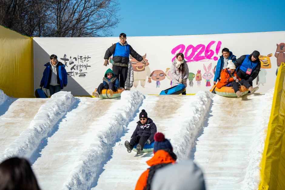
Set amid the spectacular winter landscape of the Hantangang River, the Cheorwon Hantangang River Ice Trekking Festival is one of Cheorwon’s premier winter celebrations. The festival has been inducted into the Hall of Fame of the Korea Festival Contents Awards and was selected as an Outstanding Festival by the Ministry of Culture, Sports and Tourism for 2026–2027. Connected to the Hantangang River Mulwit-gil trekking course, the festival allows visitors to enjoy the river’s breathtaking snowy scenery while taking part in a variety of performances and winter-themed activities held throughout the
Source: Korea Tourism Organization (official English translation, TourAPI).
What happens at Cheorwon Hantangang River Ice Trekking Festival
- Hantangang River Ice Trekking Course
- Main Festival Venue beneath Seungilgyo Bridge
- Ttongbaram Altong Road Run
Official programme as registered with the Korea Tourism Organization for the most recent edition. Details can change — check with the organizer before you go.
🇰🇷 Copy this into Naver Map or Kakao Map
Google Maps cannot give walking or transit directions inside Korea — Korean law restricts map-data export. Naver Map and Kakao Map can, but they find far more when you search in Korean. Copy and paste:
📊 How busy this area gets
Visitor-volume index for 철원군, from Korea Tourism Organization big data. 1.00 = that area's own yearly average, so this compares the area against itself — not against Seoul.
The index covers the whole district, not the festival ground itself. Use it to pick a month, not a day. · Aug 1.09 / Oct 1.59
🅿️ Nearby attractions — with actual parking capacity
Most sites only say "parking available." These are official figures from the Ministry of the Interior and Safety, so you can judge before you drive.
Names and addresses here stay in Korean on purpose. Google Maps cannot give directions inside South Korea, and NAVER Map / KakaoMap find these places only under their Korean names — copy an address above and paste it straight in.
🏮 Traditional market days during the festival
Korean country markets open only on days ending in fixed digits — every 5 days. These are the actual dates they open while the festival runs, so you can add one to the same trip.
Names and addresses here stay in Korean on purpose. Google Maps cannot give directions inside South Korea, and NAVER Map / KakaoMap find these places only under their Korean names — copy an address above and paste it straight in.
🎪 Other festivals nearby at the same time
Overlapping dates, within 60 km.
Nearby Attractions
Places near the festival venue, described in English by the Korea Tourism Organization. Distances and times are road-based driving estimates from NAVER route search — useful for taxi trips — and can change with traffic. Places under 1 km in a straight line are marked “walkable”. Anything more than 15 km away by road is left out.
-
Cheorwon Hantangang Milky Way Bridge철원 한탄강 은하수교 Attraction0.7 km straight · walkable
The area of Hantangang River is a UNESCO Global Geopark. The Milky Way Bridge was built to follow a natural path and allows visitors to journey comfortably. The name of…
Korean address for map apps강원특별자치도 철원군 동송읍 장흥리 -
Hantangang River [National Geopark]한탄강(국가지질공원, 고석정 Attractionapprox. 5.5 km · ~9 min by car
Goseok Rock, located in the area of Hantangang River, is a granite rock that reach 15 meters in x_height. The area is often called Goseokjeong, named after the nearby…
Korean address for map apps강원특별자치도 철원군 동송읍 태봉로 1825 -
Goseokjeong National Tourist Area고석정국민관광지 Attractionapprox. 5.6 km · ~9 min by car
Goseokjeong Pavilion is the most scenic spot among the eight scenic views of Cheorwon. The crystal clear waters of the Hantangang River wind around Goseokbawi Rock, a…
Korean address for map apps강원특별자치도 철원군 동송읍 태봉로 1825 -
Cheorwon Facilities Management Office (Formerly, Iron Triangle Battlefield철원 시설물관리사업소 (구 철의삼각전적관 Attractionapprox. 5.6 km · ~9 min by car
Located in Goseokjeong National Tourism Site, Cheorwon Facilities Management Office is the main tourism center hosting the Cheorwon tour. Starting from Security Tourist…
Korean address for map apps강원특별자치도 철원군 동송읍 장흥리 20-1 -
The 2nd Tunnel제2땅굴(철원 Attractionapprox. 5.8 km · ~10 min by car
The 2nd Tunnel, one of several excavated by North Korea for the purpose of infiltrating South Korea, was discovered in 1975. Spanning a total length of 3.5 kilometers,…
Korean address for map apps강원특별자치도 철원군 동송읍 양지리
Google Maps cannot provide driving or transit directions inside South Korea. Paste the Korean addresses above into NAVER Map or KakaoMap — both work with these addresses and are what people here actually use.
Other festivals in Gangwon
← Browse all festivals in Gangwon
Taking the trip home
A small Korean brand called kory puts city names on everyday things — hair rollers, hair ties, claw clips, scarves.
We help make kory, so this is not a paid placement — but it is a link we have an interest in. That is why it sits here at the bottom and nowhere else. Product pages and the shop home are in English; a few other pages there are still Korean only.