Home › Festivals › Pyeongchang Trout Festival
Pyeongchang Trout Festival
- 📅 Dates
- Jan 9, 2026 – Feb 9, 2026
- 📍 Location
- 3562, Gyeonggang-ro, Jinbu-myeon, Pyeongchang-gun, Gangwon-do
- 🎫 Admission
- Paid
- 🕘 Hours
- 09:00 ~ 17:00
- 🎪 Venue
- Pyeongchang Trout Festival Venue
- 🏛️ Organizer
- Pyeongchang Trout Festival Committee
- ☎️ Contact
- +82-33-336-4000
⚠️ This festival's listed dates have passed
The dates above are from the most recent official schedule. Many Korean festivals are annual events held around the same time each year, but the next date has not been officially confirmed yet — please check the official website or a Google search below before planning a trip.
Overview
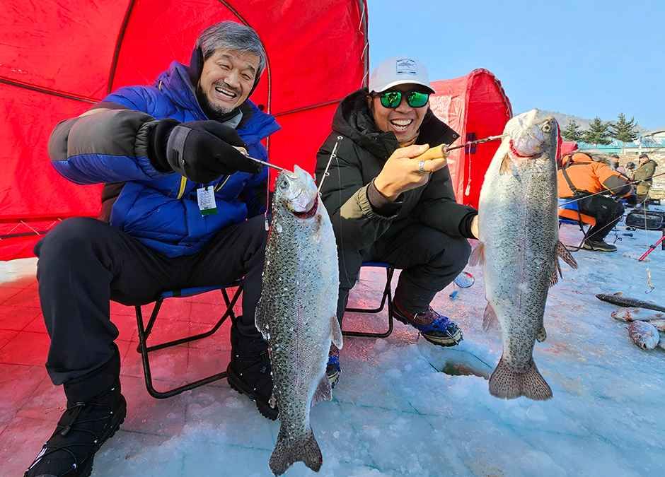
In the past, winters in this region were unforgiving. Heavy snowfalls buried villages, and neighbors would stretch ropes between their homes, carving tunnels through the snow to find their way from one house to another. When the bitter winds sweeping across the river caused the shallow channels to freeze and merge early in the season, people would hammer at large rocks beneath the ice catch fish and secure a precious meal. Today, the hardships endured by our ancestors have been transformed into celebration. Every year from late December through late January, the Pyeongchang Trout Festival brin
Source: Korea Tourism Organization (official English translation, TourAPI).
What happens at Pyeongchang Trout Festival
- Ice Fishing
- Tent Fishing
- Children’s Fishing Zone
- Golden Trout Bare-Handed Catching
- and Ice Plaza Activities
Official programme as registered with the Korea Tourism Organization for the most recent edition. Details can change — check with the organizer before you go.
🇰🇷 Copy this into Naver Map or Kakao Map
Google Maps cannot give walking or transit directions inside Korea — Korean law restricts map-data export. Naver Map and Kakao Map can, but they find far more when you search in Korean. Copy and paste:
📊 How busy this area gets
Visitor-volume index for 평창군, from Korea Tourism Organization big data. 1.00 = that area's own yearly average, so this compares the area against itself — not against Seoul.
Jan — 1.12
The index covers the whole district, not the festival ground itself. Use it to pick a month, not a day. · Oct 1.04 / Aug 1.35
🅿️ Nearby attractions — with actual parking capacity
Most sites only say "parking available." These are official figures from the Ministry of the Interior and Safety, so you can judge before you drive.
Names and addresses here stay in Korean on purpose. Google Maps cannot give directions inside South Korea, and NAVER Map / KakaoMap find these places only under their Korean names — copy an address above and paste it straight in.
🏮 Traditional market days during the festival
Korean country markets open only on days ending in fixed digits — every 5 days. These are the actual dates they open while the festival runs, so you can add one to the same trip.
Names and addresses here stay in Korean on purpose. Google Maps cannot give directions inside South Korea, and NAVER Map / KakaoMap find these places only under their Korean names — copy an address above and paste it straight in.
Nearby Attractions
Places near the festival venue, described in English by the Korea Tourism Organization. Distances and times are road-based driving estimates from NAVER route search — useful for taxi trips — and can change with traffic. Places under 1 km in a straight line are marked “walkable”. Anything more than 15 km away by road is left out.
-
Pyeongchang Sightseeing Taxi Platform평창관광택시(관광택시 플랫폼 Attractionapprox. 2.2 km · ~4 min by car
The Pyeongchang Sightseeing Taxi offers a comprehensive package that includes visits to major attractions in Pyeongchang. This taxi tour covers destinations such as Farm…
Korean address for map apps강원특별자치도 평창군 진부면 송정길 110 -
Odaesan National Park오대산국립공원 Attractionapprox. 11.2 km · ~14 min by car
Odaesan National Park, home to the towering Birobong Peak at an altitude of 1,563 meters and five other significant peaks, is a treasure trove of natural beauty and…
Korean address for map apps강원특별자치도 평창군 진부면 오대산로 2 -
Alpensia Ski Resort알펜시아리조트 스키장 Travel courseapprox. 14.8 km · ~16 min by car
Alpensia Ski Resort has six slopes for skiers and snowboarders to enjoy. Runs as long as 1.4 kilometers provide a dynamic experience for both beginners and experienced…
Korean address for map apps강원특별자치도 평창군 대관령면 솔봉로 325 -
Woljeongsa Temple & Needle Fir Forest월정사.월정사전나무숲 Attractionapprox. 13.2 km · ~18 min by car
Woljeongsa Temple, established in 643 during the Silla dynasty, is located on Odaesan Mountain. It's renowned for its historical and cultural treasures, including an…
Korean address for map apps강원특별자치도 평창군 진부면 오대산로 374-8 -
Odaesan Seonjaegil Trail오대산 선재길 Travel courseapprox. 13.3 km · ~18 min by car
Seonjaegil Trail, a course famous for its beautiful foliage along the valley in autumn, is a 9-kilometer forest road from Woljeongsa Temple to Sangwonsa Temple. It is a…
Korean address for map apps강원특별자치도 평창군 진부면 오대산로 374-8
Google Maps cannot provide driving or transit directions inside South Korea. Paste the Korean addresses above into NAVER Map or KakaoMap — both work with these addresses and are what people here actually use.
Other festivals in Gangwon
← Browse all festivals in Gangwon
Taking the trip home
A small Korean brand called kory puts city names on everyday things — hair rollers, hair ties, claw clips, scarves.
We help make kory, so this is not a paid placement — but it is a link we have an interest in. That is why it sits here at the bottom and nowhere else. Product pages and the shop home are in English; a few other pages there are still Korean only.