Home › Festivals › Dongnaeeupseong History Festival
Dongnaeeupseong History Festival 2026
- 📅 Dates
- Oct 16, 2026 – Oct 18, 2026
- 📍 Location
- 80, Munhwa-ro, Dongnae-gu, Busan
- 🎫 Admission
- Free
- 🕘 Hours
- Opening event 18:00-19:10 / Main event 10:00-18:00
- 🎪 Venue
- Areas of Dongnae Culture Center and Dongnaeeupseong Walled Town
- 👥 Age
- Open to visitors of all ages
- 🏛️ Organizer
- Dongnae-gu · Dongnae Culture Center, Dongnaeeupseong History Festival Organizing Committee
- ☎️ Contact
- +82-51-550-4092
Overview
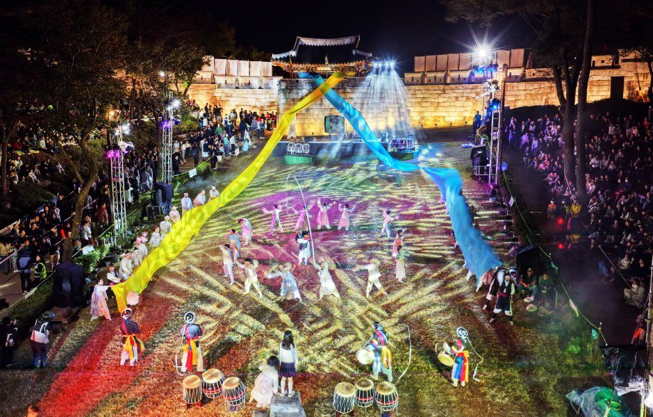
*The information below is based on the 2025 festivals. Details for the 2026 festivals will be updated as they become available.*The Dongnaeeupseong History Festival offers an immersive experience of the history and culture of Dongnaeeupseong Walled Town, where the Battle of Dongnaeseong Fortress took place against the Japanese army during the Imjin War in 1592. Highlights include a musical dramatizing the patriotic spirit of the Dongnae Governor during the battle and various hands-on experiences, such as participating as Dongnae citizens using traditional Joseon-era coins.
Source: Korea Tourism Organization (official English translation, TourAPI).
🅿️ Nearby attractions — with actual parking capacity
Most sites only say "parking available." These are official figures from the Ministry of the Interior and Safety, so you can judge before you drive.
Names and addresses here stay in Korean on purpose. Google Maps cannot give directions inside South Korea, and NAVER Map / KakaoMap find these places only under their Korean names — copy an address above and paste it straight in.
🏮 Traditional market days during the festival
Korean country markets open only on days ending in fixed digits — every 5 days. These are the actual dates they open while the festival runs, so you can add one to the same trip.
Names and addresses here stay in Korean on purpose. Google Maps cannot give directions inside South Korea, and NAVER Map / KakaoMap find these places only under their Korean names — copy an address above and paste it straight in.
🎪 Other festivals nearby at the same time
Overlapping dates, within 60 km.
Nearby Attractions
Places near the festival venue, described in English by the Korea Tourism Organization. Distances and times are road-based driving estimates from NAVER route search — useful for taxi trips — and can change with traffic. Places under 1 km in a straight line are marked “walkable”. Anything more than 15 km away by road is left out.
-
Site of Dongnaeeupseong Walled Town동래읍성지 Attraction0.9 km straight · walkable
Site of Dongnaeeupseong Walled Town, built towards the end of the Goryeo dynasty and the early Joseon dynasty, was a significant fortress during the Imjin War in 1592.…
Korean address for map apps부산광역시 동래구 동래역사관길 18 (복천동) -
Hurshimchung허심청 Attractionapprox. 1.5 km · ~7 min by car
Hurshimchung is an urban hot springs facility that pursues health promotion through comfortable and enjoyable hot spring bathing, relaxation, and physical training. It…
Korean address for map apps부산광역시 동래구 온천장로107번길 32 (온천동) -
Geumgang Park금강공원 Attractionapprox. 2.3 km · ~10 min by car
Geumgang Park is a park located at the foot of Geumjeongsan Mountain, near the Dongnae Hot Springs Area. It features lush forests of naturally grown trees, majestic…
Korean address for map apps부산광역시 동래구 우장춘로 155 -
Busan Sports Complex Sajik Baseball Ground부산사직종합운동장 사직야구장 Travel courseapprox. 5.2 km · ~18 min by car
Located within the Busan Sports Complex, Busan Sajik Baseball Ground was completed in October 1985 and has served as the home stadium of the Lotte Giants since 1986. The…
Korean address for map apps부산광역시 동래구 사직로 45 -
Busan Asiad Main Stadium부산 아시아드주경기장 Travel courseapprox. 5.4 km · ~18 min by car
Busan Asiad Main Stadium, completed in 2001, was constructed to host the 2002 World Cup and the 2002 Busan Asian Games. Its design, closer to a circle than a straight…
Korean address for map apps부산광역시 연제구 월드컵대로 344
Google Maps cannot provide driving or transit directions inside South Korea. Paste the Korean addresses above into NAVER Map or KakaoMap — both work with these addresses and are what people here actually use.
Other festivals in Busan
← Browse all festivals in Busan
Taking Busan home
A small Korean brand called kory puts city names on everyday things — hair rollers, hair ties, claw clips, scarves.
We help make kory, so this is not a paid placement — but it is a link we have an interest in. That is why it sits here at the bottom and nowhere else. Product pages and the shop home are in English; a few other pages there are still Korean only.